SouthYorks
Forum Replies Created
-
AuthorPosts
-
February 2, 2021 at 10:20 am #521
 SouthYorksParticipant
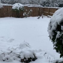
Well we ended up with a decent covering in Barnsley, probably around 4-5 inches. Boundary seems to have been around Chesterfield in Derbyshire then all snow in Yorkshire. We got about 8-9 hours of at times moderate snow from around 2am. Last nights Arpege aligned quite nicely with the Meto Amber warning in terms of location and depth of snow. Here are a few pics as a taster of what is hopefully to come from this weekend and into next week!
Attachments:
You must be logged in to view attached files.January 29, 2021 at 10:58 pm #511 SouthYorksParticipant
18z ICON, GFS and GFS para are all similar in that they all have a period of snow for Tuesday currently before a change back to rain Wednesday and then colder air returning in Thursday. ICON and Para look best for most snow, with GFS moving the pon faster and with a fairly speedy transition to rain.
No doubt at this range there will be more chopping and changing as we countdown to next week.
Attachments:
You must be logged in to view attached files.January 29, 2021 at 10:39 am #508 SouthYorksParticipant
6z ICON is looking rather good for snow in our region next Tuesday/Wednesday!
Attachments:
You must be logged in to view attached files.January 28, 2021 at 8:17 am #506 SouthYorksParticipant
For Saturday, GFS now has the snow furthest North with it scraping into South Yorkshire before returning South and fizzling out. ECM and ICON are a bit further South with snow making it to Derbyshire. GFS para and Arpege have the snow barely reaching Birmingham, so this is looking like another Midlands event to me.
January 26, 2021 at 7:47 pm #502 SouthYorksParticipant
Arpege now seems to have aligned to ECM, so snowfall now looks like being confined to highest ground of North West Yorkshire.
Next potential snow event is looking like Sunday into Monday for our region if ECM is correct.
Further out, days 9/10, according to GFS we could could be going into a period of very cold temps with Easterlies showing up bring8ng snow to more lowland areas on the East side of the country.
January 26, 2021 at 12:00 pm #499 SouthYorksParticipant
Meto Yellow warning for snow on Thursday seems to take a middle ground somewhere between Arpege 6z and ECM 0z.
A band of snowfall will likely push northeast into this region during the early hours of Thursday and become slow-moving. Snow may fall to lower elevations for a time with some locations seeing several cm by morning, however above 200 m elevation significant and prolonged snowfall is possible throughout Thursday, with the potential for 15-30cm to accumulate which may lead to transport disruption. Overnight into Friday snowfall will turn lighter and more patchy, and likely become restricted to elevations above 300-400 M, but may see a further 5-10 cm.
Attachments:
You must be logged in to view attached files.January 25, 2021 at 11:14 pm #495 SouthYorksParticipant
Arpege 18z continuing with the snowy theme for Thursday.
Attachments:
You must be logged in to view attached files.January 25, 2021 at 7:21 pm #486 SouthYorksParticipant
According to both ECM and Arpege 12z runs, large parts of our region could get a pasting on Thursday.
Attachments:
You must be logged in to view attached files.January 25, 2021 at 8:51 am #479 SouthYorksParticipant
Arpege continues with a wintery outlook for Thursday, although at the moment it seems out in its own!
Attachments:
You must be logged in to view attached files.January 24, 2021 at 5:11 pm #472 SouthYorksParticipant
Potentially another snow event on Tuesday, but according to Arpege Thursday looks more interesting
Attachments:
You must be logged in to view attached files.January 24, 2021 at 7:04 am #465 SouthYorksParticipant
Looks like todays snow will be mostly to the South of our region, with the pivot point being in the Midlands. Models have the northern extent in a line south Lincolnshire/Wash across to North Wales. Icon is slightly further North taking some snow into North Derbyshire/South Yorkshire/Manchester.
Attachments:
You must be logged in to view attached files.January 23, 2021 at 1:47 pm #440 SouthYorksParticipant
Not sure the majority will see much more today, maybe a few flurries but that is about it away from higher ground in the very South of the region.
Next potential interest again for the South of our region maybe tomorrow according to WRF-NMM, which brings the snow a bit further North compared other models.
After that, according to Harmonie, another potential band of snow moving North to South on Monday morning.
Attachments:
You must be logged in to view attached files.January 23, 2021 at 10:04 am #433 SouthYorksParticipant
Anyone care to explain the snow disappearing over Huddersfield and reforming again over Wakefield, Seen this before and its bloody annoying
Often get the same with Barnsley. Seems to look good out West then disappears when it gets here only for it to re-intensify when it gets to Doncaster. Same whether it’s rain or snow.
January 23, 2021 at 9:24 am #429 SouthYorksParticipant
Trough looks to be moving East South East so unless it disipates as it hits the highest ground, West and South Yorkshire should see some snow falling in a few hours.
-
This reply was modified 4 years, 4 months ago by
 SouthYorks.
January 22, 2021 at 11:44 am #403 SouthYorksParticipant
Yellow weather warning issued for snow and ice, covering Friday, Saturday and Sunday. Potential for accumulations at low levels well as high ground.
From models, looks like shower activity tonight and tomorrow and then risk from approaching front on Sunday. Tonight and tomorrow therefore, some areas may get lucky whilst others see nothing. Still lots of uncertainty regards track of front on Sunday with some models bringing it in across our region and others taking in a more Southerly route and missing us altogether.
-
This reply was modified 4 years, 4 months ago by
-
AuthorPosts