Northern England, (NW & Yorkshire) weather discussion January 2021
- This topic has 271 replies, 21 voices, and was last updated 4 years, 4 months ago by
Had Worse.
-
AuthorPosts
-
January 30, 2021 at 12:44 pm #514
 Jeremy SParticipantJanuary 30, 2021 at 12:50 pm #515Jeremy SParticipant
still cant post attachements ….but Tue a.m looking very interesting on WRF short range @ 70 hrs
January 30, 2021 at 1:35 pm #516Withington, Manchester, 38m ASL
ParticipantNext Tuesday looks decent. Less precipitation shadow potential. Need southwards corrections.
Very keen to hear your thoughts Kasim 🙂 . ICON is my favourite outcome atm.
January 30, 2021 at 1:44 pm #517 Raul AlonsoParticipant
Yep looking good for Tue.. what are your thoughts so far Kas?
https://www.wunderground.com/dashboard/pws/ISALE43
January 31, 2021 at 7:02 pm #518 Kasim AwanKeymaster
Tuesday is now looking like a Leeds/ Bradford NE event similar to the one in Feb 2020. Only a small chance, say 25%, of positive southwards corrections.
January 31, 2021 at 10:26 pm #519Raul AlonsoParticipantProbably our next opportunity here in Mcr area will be late on the week.. Sun-Mon then will see how the easterly pans out..
https://www.wunderground.com/dashboard/pws/ISALE43
February 1, 2021 at 9:31 pm #520Kasim AwanKeymasterTomorrow morning – heavy wet snow 1-4cm below 100m much of Yorkshire, increasing to 30m perhaps Hawes, Harrogate.
Wet snow to freezing rain on the west Pennines, rain/sleet roughly sw of Oldham.February 2, 2021 at 10:20 am #521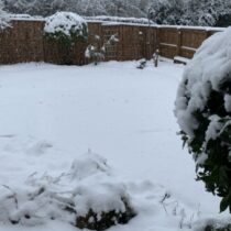 SouthYorksParticipant
Well we ended up with a decent covering in Barnsley, probably around 4-5 inches. Boundary seems to have been around Chesterfield in Derbyshire then all snow in Yorkshire. We got about 8-9 hours of at times moderate snow from around 2am. Last nights Arpege aligned quite nicely with the Meto Amber warning in terms of location and depth of snow. Here are a few pics as a taster of what is hopefully to come from this weekend and into next week!
Attachments:
You must be logged in to view attached files.February 2, 2021 at 7:42 pm #526Had Worse
ParticipantHad a mini blizzard this morning at 3am but wasnt sticking, woke at 6.30 am and it was heavy snow and just about covering the road. By the time I got out of the shower, it had stopped and the melting was progressing.
Welcome to Royston Vasey, You'll Never Leave.
February 2, 2021 at 7:56 pm #527Wirral snow starved peninsular
ParticipantIs there no hope of you returning to the dark side on NW Kasim? I keep forgetting to look in here 🥲
February 2, 2021 at 8:47 pm #528ParticipantI suppose he could under a different alias but that wouldnt be the point.
Constructing very educational posts and valid arguments, then having it all deleted and without reason was the tipping point.The regionals are ok but post on the MOD thread at your own risk.
Welcome to Royston Vasey, You'll Never Leave.
February 2, 2021 at 9:36 pm #529Kasim AwanKeymasterI have had a chat with the admins on there and they have agreed to unblock my netweather account.
I will continue to post on here for now. I opened this forum up to vent my meteorological ideas really – haven’t had much chance to use it properly been so clogged up with various other bits.
At present next week holds a lot of interest for central and eastern areas of the region. Under the ECM/GFS scenario there would be adequate air mixing (low heights) to drive westerly advancement of precip to say the M6 corridor. This combined with fronting & elevation >100m in the East could result in very nice wintry conditions. Keep an eye on output.
-
This reply was modified 4 years, 4 months ago by
 Kasim Awan.
February 2, 2021 at 9:46 pm #530Kasim AwanKeymasterP.s. I have released this new travel website for the Peak District. Covers A57, A628, etc.
<<http://peakweathereye.co.uk>>
peakweathereye.co.uk
-
This reply was modified 4 years, 4 months ago by Kasim Awan.
February 2, 2021 at 10:30 pm #533Participant
Glossop Online from sheffield
This confirms that Chris, the coder on Glossop Online sadly passed away.I hope you can emulate his site.
Welcome to Royston Vasey, You'll Never Leave.
February 2, 2021 at 10:41 pm #534Kasim AwanKeymasterThanks Hadworse. It was an excellent site and Chris was clearly a seasoned coder… I am more of a novice coder / website manager and lack the experience Chris had. He used live accident data from private highways information service providers such as InRix. I can’t afford InRix right now, it’s £5000 for a basic annual licence. The TomTom API (which I currently use) does provide incident data, which is probably 70% of the functionality of InRix for just £200 a year. This is what I will try and utilize for the incident data. Atm the site uses basic TomTom segment speed & closure status API (API = internet data service), and manual reports. This produces the speed & closure status widgets for each road. I’ve already done quite a bit with the weather stuff, inc live air AND road surface temperature, plus cloud base altitude which is almost ready to go live on the site..
Plan: incorporate automated live incident data with info on time since report -
This reply was modified 4 years, 4 months ago by
-
AuthorPosts
- You must be logged in to reply to this topic.